Panic Disorder 411
Canoeing On The Chapleau River In northern Ontario

The Chapleau Region
Chapleau is located in the heart of the Canadian Shield, a
large area of exposed Precambrian igneous and high-grade
metamorphic rocks that form the ancient geological core of the
North American continent, and are covered by a thin layer of
soil. It is an area mostly composed of igneous rock, which
relates to its long volcanic history. It has a deep, common,
joined bedrock region in Eastern and Central Canada that
stretches North from the Great Lakes to the Arctic Ocean,
covering over half of Canada. It also extends South into the
Northern reaches of the United States. Human population is
sparse, and industrial development is minimal, while mining is
very prevalent.
The Canadian Shield extends into the United States as the
Adirondack Mountains and the Superior Upland. The Canadian Shield
is the area of greatest glacial impact scraping down to bare
rock, creating the thin soils, and is more than 3.96 billion
years old. The Canadian Shield once had jagged peaks, higher than
any of today's mountains, but millions of years of erosion have
changed these mountains to rolling hills.
The Canadian Shield was the first part of North America to be
permanently elevated above sea level and has remained almost
wholly untouched by successive encroachments of the sea upon the
continent. It is the Earth's greatest area of exposed Archean
rock.
The multitude of rivers and lakes in the entire region is caused
by the watersheds of the area being so young and in a state of
sorting themselves out with the added effect of post-glacial
rebound. The Shield was originally an area of very large
mountains (39,000 feet) with much volcanic activity, but over
hundreds of millions of years, the area has been eroded to its
current topographic appearance of relatively low relief. It has
some of the oldest (extinct) volcanoes on the planet. It has over
150 volcanic belts (now deformed and eroded down to nearly flat
plains), whose bedrock ranges from 600 million to 1.2 billion
years old.1
The Town
Chapleau is located in central, Northeastern Ontario, in the
heart of the Canadian Shield. Chapleau is geographically
isolated; the nearest cities are Sault Ste. Marie, Timmins, and
Sudbury, but all are more than a two-hour drive away.
With over 2,700 square miles of land, the Chapleau Crown Game
Preserve, north of the town, is the largest animal preserve in
the world. Protected wildlife include moose, black bears, pygmy
shrews, bald eagles and loons. All forms of hunting and trapping
have been forbidden in the preserve since the 1920s. The result
is an area with abundant wildlife. Over 2,500 moose and over
2,000 black bears reside within the game preserve. Logging does
occur within the preserve, as does fishing.2
The Chapleau Crown Game Preserve

The River
From its source in Chapleau, Ontario to its mouth in the Chapleau-Nemegosenda River Provincial Park, the course of the wild and untamed Chapleau River is 65 miles and is accessible only by canoe. It widens to more than a thousand feet to become a lake and can narrow to less than a hundred feet in other areas. Miles of whitewater rapids, lakes and short portage points, where the river disappears, provide for the experience of a lifetime in this pristine land.
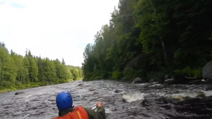
Entering The Rapids On The Chapleau River
The Course of Chapleau River

The Canoe Trip
We left our camp near Jackson, Michigan early in the morning
on a bus packed with supplies, a trailer toting 6 Grumman
aluminum canoes, a guide and 11 boys, teaming with enthusiasm.
Our destination was Chapleau, Ontario, a hamlet about 200 miles
north of Sault Ste. Marie. Except for the guide, we were all only
16, yet we were strong swimmers with an expertise in canoeing and
miles of practice under our belts on the waterways in the
Waterloo Recreation Area in Central Michigan and elsewhere. It
was the summer of 1962, long before the advent of computers and
mobile phones. We knew that we had to live up to our expert
reputations when we embarked on the wild, untamed Chapleau River
in the Chapleau wilderness, an area accessible only by boat. We
knew that our lives depended upon our skill.
We were trained in all aspects of canoeing, including paddle
strokes, righting a capsized canoe in deep water, and portaging.
The paddle strokes weren't difficult to learn, but took a lot of
practice to perfect. The sternsman's job was to navigate the
canoe in calmer waters, by using the J-stroke, which kept the
canoe traveling forward in a straight line, and the sweep-stroke
to turn the canoe. The bowsman's job was to provide power for the
forward movement of the canoe. The bowsman's job became crucial
in running rapids since he was the first to see rocks that were
submerged just below the surface and used the point-stroke and
other maneuvers to avoid hitting them. The sternsman usually
couldn't see submerged rocks until it was too late.
Uprighting a capsized canoe in deep water is a fairly simple
process when you have a buddy canoe nearby. The buddy canoe is
positioned perpendicular to the capsized canoe, which is then
turned bottom side up and slowly pulled over the center of the
upright canoe, allowing water to drain into the waterway. The
canoe is carefully turned upright and pushed back into the
water.
We arrived in Chapleau late in the afternoon and planned to camp
on a site on the river, a short distance from the town. The main
street in the downtown area was a dirt road, and the buildings
were old, wood frame structures. It's interesting that this town,
that some would consider to be a backward community, installed a
wireless mesh network in 2005, the first of its kind in Canada.
[2] The Chapleau Crown Game Reserve is a long standing example of
the love and stewardship that local residents exhibit in
conserving the earth's wilderness.
From our first launch, we became a part of that stewardship,
influenced by the beauty of the wilderness river, pristine as it
was when the first explorers visited the area. We felt like
pioneers in our own right. We camped that night on bedrock in a
clearing by the side of the river a couple of miles from
Chapleau, a campsite that was typical of the ones we would find
in the days to follow. We pitched our tents, gathered wood for a
fire, prepared dinner, sat for a time by the embers and looked
into the pitch black sky with a million stars shining over
us.
At dawn's first light, we watched moose on the opposite bank
drinking from the river, a common sight on our journey. We ate
breakfast—hotcakes, spam and dehydrated eggs, brought to
life from water from the river. We packed our tents and stowed
our gear in the canoes and shoved off for our first day of
adventure. We traversed Chapleau Lake and shot down 7 Mile
Rapids, an exciting ride, then camped for the night. The next day
(Day 2), we explored the islands in Henderson Lake and camped on
the north shore for the night. The following day (Day 3), a short
day of canoeing, we camped north of D'Arcy Lake, near 18 Mile
Rapids, swam in the river in the afternoon and rested for our
next day on the rapids. In the morning (Day 4), we shot the
rapids and camped on the shore of Robinson Lake. On the fifth
day, we had two portages before we arrived at the road that would
lead home.
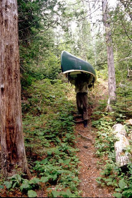
The portages were difficult due to underbrush and uneven ground.
With a man on the bow and a man on the stern, we lifted the
canoes over our heads and supported the craft on our arms. The
portages were about a quarter of a mile, and we had to return for
our gear after we reached the river again.
Our trip down 7 Mile Rapids went as smoothly as could be
expected. Occasionally, a canoe would approach a submerged rock,
and we would correct our course as we moved forward. Finding
ourselves jammed into a bank of the river, we would push out
toward the flow of the river and proceed on our journey. We found
ourselves intact in the calmer waters at the base of the rapids,
and none of the canoes capsized.
Downriver, where the water calmed, we found a resting spot
onshore among the large boulders, a refuge, where we could think
of the thrill of riding the rapids to victory. Yet, we knew as we
continued on our journey that other swift rapid runs awaited with
more thrilling challenges.
We could hear the roar of 18 Mile Rapids from a bend in the river
near the whitewater. Our guide gave the command for the first
canoe to proceed around the bend into the rapids, waiting a
couple of minutes to give the okay for the second canoe to leave.
We left a lot of room between canoes in the event that one of
them ran into trouble, snagging on a rock or a low hanging branch
over the river, which became obstacles for the canoes that
followed.
At the bottom of the rapids, where the whitewater ended, there
was still a heavy current pulling the canoes downstream. A
hundred yards into the calmer waters around a bend in the river,
a tree branch was cantilevered across the river, with no room to
go around it. The first canoe hit the branch and capsized, with
the second following in its place. The other canoes made it to a
clearing on shore, and we waded in the shallow water to help the
boys in the capsized canoes. We rested for a half hour, then
walked down the trail to see what lay ahead. A few feet down the
trail, we began to hear the roar of water falling. Fifty yards
later, we saw a waterfall, 20 feet high. We knew immediately that
we had avoided peril by running into the large tree branch over
the river.
Once we entered the rush of whitewater rapids, there was no
turning back. We could only hope to avoid rocks and obstacles in
our path with the pointing stroke of the bowsman and the backward
stroke of the sternsman. We discovered on our journey that
obstacles to navigation could be a good thing. Either nature or a
good Samaritan had placed that branch in our path so we couldn't
move forward, forcing us to avoid the danger of the waterfall
that lay ahead.
On our journey, we learned to leave our campsites as pristine as
we found them. Part of conservation is to leave a minimal
footprint on the wilderness.
One of the great lessons we learned from our adventures on the
Chapleau River, in the wild, untamed land in Northern Ontario,
was that we were meant to be stewards of the earth. We belong to
the land for a brief period of time. The land doesn't belong to
us. As the global population continues to grow, and cities
continue to encroach on nature, we have to find ways of
protecting our natural environments.
We loaded and boarded the bus that would take us home. Before we
left, we could see a large, black bear standing on its hind legs
in the woods nearby. He seemed to be looking at us. It was almost
like he was bidding us farewell.
Credits
1 Canadian Shield
2 Chapleau, Ontario
Story by Michael Jackson Smith